A poem in praise of Paris
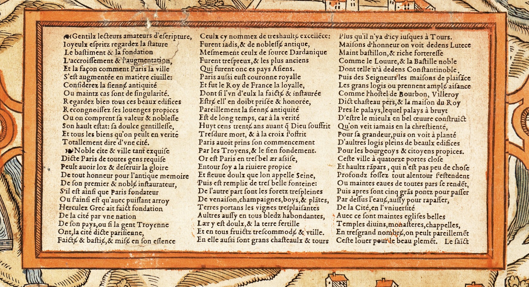
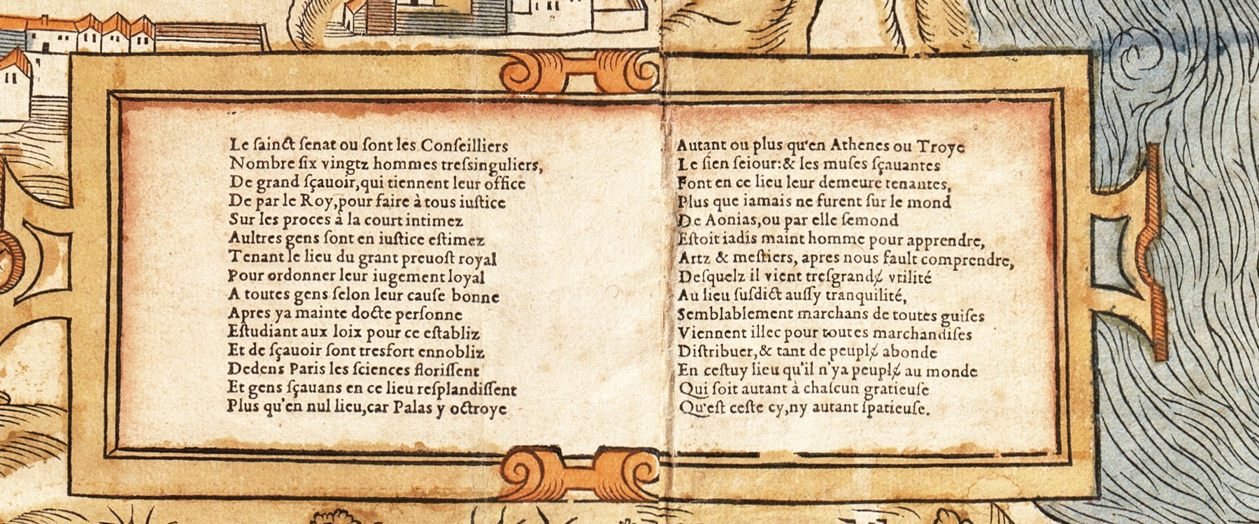
The poem starts in the large panel at the lower left and carries on in the smaller panel in the middle, linked by the catchword “Le sainct” at the foot of the first. It is by Gilles Corrozet: the first letters of its first fourteen lines spell his name. It is his “Louenges de Paris”, printed in his Fleur des antiquitez de Paris in 1532 and lightly revised for the map (see the notes). It is in rhyming couplets of ten syllables. It runs through the city's legendary founding, its setting, its castles and great houses, its walls, bridges and churches, its courts, its university and its trade.
Notes
- An acrostic (lines 1–14): the opening stanza, which ends at the printer's ornament before line 15, spells GILLES CORROSET with the first letters of its lines: Gilles Corrozet (1510–1568), bookseller at the Palais and author of the first guidebooks to Paris, the Fleur des antiquitez (1532) and the Antiquitez de Paris (1550). In the Fleur the stanza is headed “Le nom et surnom de l'aucteur” (the author's name and surname) and the poem “Louenges de Paris faictes par ledict aucteur” (praises of Paris by the said author); the map leaves both headings out. Jules Cousin was the first to point the name out on the map, in 1875. We found no other acrostic: not in the rest of the poem (first or last letters, by stanza, column or panel), nor in the publishers' notice. See who made the map.
- Paris, Hercules, the Trojans (lines 19–41): the poem weighs the founding legends of its day without choosing. In one, Paris was founded by Trojan exiles: in Jean Lemaire de Belges' Illustrations de Gaule (1510–1513), Hector's son, renamed Francus, founds it and names it after his uncle Paris. Another, from the forged Antiquities of Annius of Viterbo (1498), made Paris a king of the Gauls (lines 32–33); a third credited Hercules. Dardanus (line 29) was the ancestor of the kings of Troy. None of this has any historical basis: the city takes its name from the Parisii, the Gaulish people who lived there.
- “Eight hundred and thirty years before God suffered” (line 38): about 800 BC by the legend's reckoning.
- Two lines without a partner: the poem rhymes in couplets, but lines 21 (arroy) and 74 (vniuersité) have no rhyme. The 1532 text has the missing partners: “Soit dudict lieu qui fut de Gaulle roy” (whether Paris, the founder, was king of Gaul) before line 21, and “Depuis la ville en la noble cite” (from the town to the noble Cité) before line 74. The count of 108 is of the lines as printed on the map.
- The map's text and the book's: compared with the Fleur of 1532, the map leaves out four lines (the two above and, after line 71, a couplet saying the enclosure takes in seven leagues) and changes about ten words. Some changes bring the facts up to date: the book has eleven gates and thick walls (unze portes, gros murs) where the map has fourteen gates and high ramparts (lines 68–69), and a hundred councillors where the map has six score (line 80). Others look like slips: propice (line 43) and plantes (line 47) break rhymes that the book's rassise and plaines make. Line 15 begins Noble on the map, Nostre (our) in the book. The book also helps with line 98: the map's par elle (by her) is par elles (by them, the Muses) there, and the translation follows the book. Who made the changes, and whether a later edition of the Fleur already had them, is not known.
- Lutetia (line 54): the Roman name of Paris.
- The Hôtel de Bourbon (line 60): the Petit-Bourbon, beside the Louvre.
- Villeroy, “château pers” (lines 60–61): the words are clear on the scan, the meaning is not. Villeroy is probably the town house of the Neufville family, lords of Villeroy, in the rue des Bourdonnais, whose oldest parts go back to about 1370; rebuilt in the 17th century, it still stands. Pers was a blue or blue-grey colour; we have found no source that explains the name.
- The King's house by the Palace (lines 61–62): the Palace is the Palais de la Cité, the old royal palace on the island, by then above all the seat of the Parlement (today's Palais de Justice). Which royal house beside it the poet means is not clear.
- Five great bridges (line 72): Pont Notre-Dame, Pont au Change and Pont aux Meuniers (a bridge of water mills) on the right arm of the Seine; Petit-Pont and Pont Saint-Michel on the left arm. All five are on the map.
- The holy senate (lines 78–83): the Parlement of Paris, the highest court of the realm, not an assembly. Francis I (r. 1515–1547) enlarged it with two new chambers of twenty members each and a score more judges. The 1532 text of the poem says a hundred councillors; the map says “six score” (120). We have not been able to confirm the exact figure.
- Standing in for the Provost (lines 84–87): tenant le lieu, “holding the place”, is what lieutenant means. The Prévôt de Paris was the king's judge for the city; his lieutenants, civil and criminal, did the judging in his name at the Grand Châtelet.
- Pallas, the Muses, Aonia (lines 93–99): Pallas Athena, goddess of wisdom; the Muses lived on Mount Helicon in Aonia, a poetic name for Boeotia in Greece. The claim: Paris and its university outshine Athens.
The publishers' notice
Notes
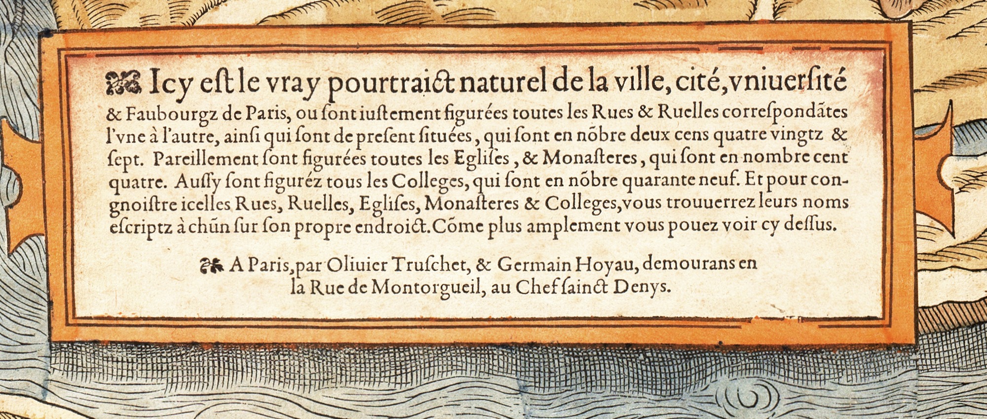
- The counts: the notice promises 287 streets and lanes, 104 churches and monasteries and 49 colleges. The labels read for this site name 219 streets, 91 churches and religious houses and 32 colleges; many more are drawn without a name (see how the labels were read).
- The publishers: the notice does not say who drew the city and who cut the woodblocks, and modern sources disagree. Both men belonged to the image-makers of the rue Montorgueil, who made large woodcut prints for hanging on walls: Truschet is recorded there in the 1550s as a cutter of pictures (tailleur d'histoires), at the sign of the Chef Saint-Denis; Hoyau later bought shares of a house nearby, the Bon Pasteur (1563 and 1566).
- The Chef Saint-Denis (the head of Saint Denis) was a house sign. Denis, first bishop of Paris, was beheaded on Montmartre and, in the legend, walked away carrying his head.
- The date: the notice gives none. Jules Cousin, who published the first facsimile in the 1870s, dated the plan about 1552; others say 1553. This site says c. 1550.
Other words on the map
- The title banner at the top: La ville, cité, université de Paris, “the town, the city and the university of Paris”: the three parts of Paris at the time, the Ville on the right bank, the Cité on the island, the Université on the left bank.
- The winds and the quarters: blowing heads in three corners and Latin names along the edges: Subsolanus (the east wind) at the top left, Oriens (east) at the top, Auster (the south wind) at the top right; Septentriones (north) at the bottom left, Occidens (west) at the bottom and Favonius (the west wind) at the bottom right. The map is printed with east at the top.
- The arms and the crescents at the top: the arms of France (golden lilies on blue, under a crown), the arms of Paris (the ship), and between France and the Subsolanus three interlaced crescents, the emblem of King Henri II (r. 1547–1559).
- BIBL. PUBL. BASILIENSIS, bottom left: the stamp of the public library of Basel. Its copy is the only one known; the librarian Louis Sieber recognised it in 1874.
About this transcription
Transcribed from the Basel copy and checked line by line against the scan. The long s (ſ) is printed as s, the æ ligature as ae, and the printer's abbreviations are written out (q̃ = que, p̄lemẽt = parlement, a tilde for a following n or m). Everything else is as printed: spelling, accents and their absence (cite, line 15), u for v and v for u, i for j, and word division (n'ya, que lon).
The translation follows the original line by line where the syntax allows, so a sentence sometimes runs across lines in a different order. The transcription and translation were made with Claude Code (see how this was built); corrections are welcome.
References
Everything the project reads from is on the Sources page.
- Gilles Corrozet, La fleur des antiquitez de la noble et triumphante ville et cité de Paris, second edition (1532), ed. P. Lacroix (“le bibliophile Jacob”), Paris, 1874, pp. 64–68: gallica.bnf.fr / BnF (the poem, with its acrostic stanza); comparison in the research notes.
- Jules Cousin, “Notice sur un plan de Paris du XVIe siècle nouvellement découvert à Bâle”, Mémoires de la Société de l'histoire de Paris et de l'Île-de-France, t. I (1875), pp. 46–59: gallica.bnf.fr / BnF (the acrostic, pp. 51–52).
- Jules Cousin, “Table des noms des rues… inscrits sur le plan de Paris publié vers 1552 par Olivier Truschet et Germain Hoyau”, Mémoires de la Société de l'histoire de Paris et de l'Île-de-France, t. I (1875), pp. 60–70: gallica.bnf.fr / BnF.
- Catherine Hofmann, “Publishing and the Map Trade in France, 1470–1670”, in The History of Cartography, vol. 3 (University of Chicago Press, 2007), ch. 53: PDF (Truschet and Hoyau, the rue Montorgueil).
- Séverine Lepape, Gravures de la rue Montorgueil (Éditions de la BnF, 2015): OpenEdition (the Montorgueil image-makers; Hoyau and the Bon Pasteur house).
- Plan de Truschet et Hoyau, Wikipédia (the Basel copy, its rediscovery in 1874).
- Francus, Wikipedia; “The Reception of Annius of Viterbo's Forgeries: The Antiquities in Renaissance France”, journals.uchicago.edu (the founding legends).
- History of France, 1490–1715, Encyclopaedia Britannica (Francis I and the Parlement of Paris).
- Châtelet, Encyclopaedia Britannica, 1911 (the Prévôt and his lieutenants).
- Hôtel de Villeroy (Paris, 1st arrondissement), Wikipedia.
- The bridges, the Palace and the Petit-Bourbon: their place pages on this site, with their own sources.
Paris 1550, by Peer Blekelj.